Scenic River Walks
Many rivers throughout the USA provide backdrops for scenic river walks. Some of the best river walks, like the Idaho Falls Greenbelt Trail, cater to people seeking a peaceful place for outdoor exercise. Others, like the Chicago Riverwalk, are designed around entertainment, boasting a variety of restaurants, bars and attractions.
Throughout history, cities built along waterways have proven more prosperous than their landlocked counterparts. Rivers and canals have long been used for trade purposes. This explains why many of the USA’s largest cities sprung up along river banks. Those rivers now serve another important purpose, having been transformed into river walks tailor-made for recreation.
From scenic green spaces to bustling entertainment districts, these are the best river walks in the USA.
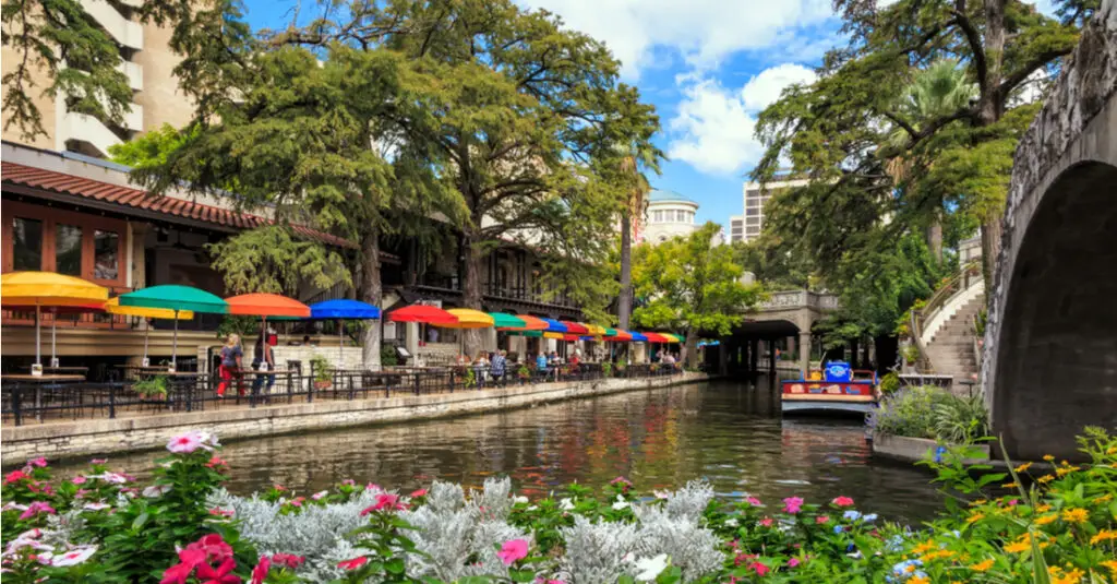
San Antonio River Walk
- Location: San Antonio, Texas
- Length: 15 miles
- River: San Antonio River
The San Antonio River Walk is the most famous river walk in the U.S., and the main attraction of San Antonio. Following the San Antonio River through the city center, the San Antonio River Walk features an array of shops, restaurants and bars. Mariachi bands provide a pleasant soundtrack as people stroll, dine or relax on a boat tour. The River Walk also connects several of San Antonio’s top attractions, including the Alamo, the San Fernando Cathedral and Hemisfair Park.
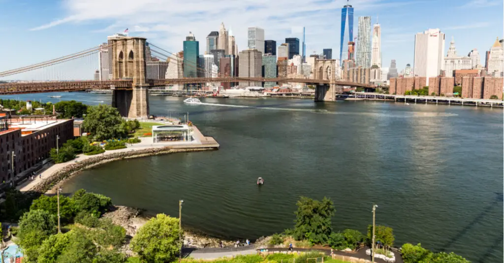
Brooklyn Bridge Park
- Location: Brooklyn, New York
- Length: 5.5 miles
- River: East River
Brooklyn Bridge Park has transformed itself from a historic transportation terminal to an 85 acre park. The most popular riverfront attraction along the East River, Brooklyn Bridge Park extends over 11 blocks. The park offers room for a variety of activities, including picnicking, playing sports, fishing and strolling. Nearby, the Shore Road Park and Parkway features an additional four-plus miles ideal for biking and hiking.

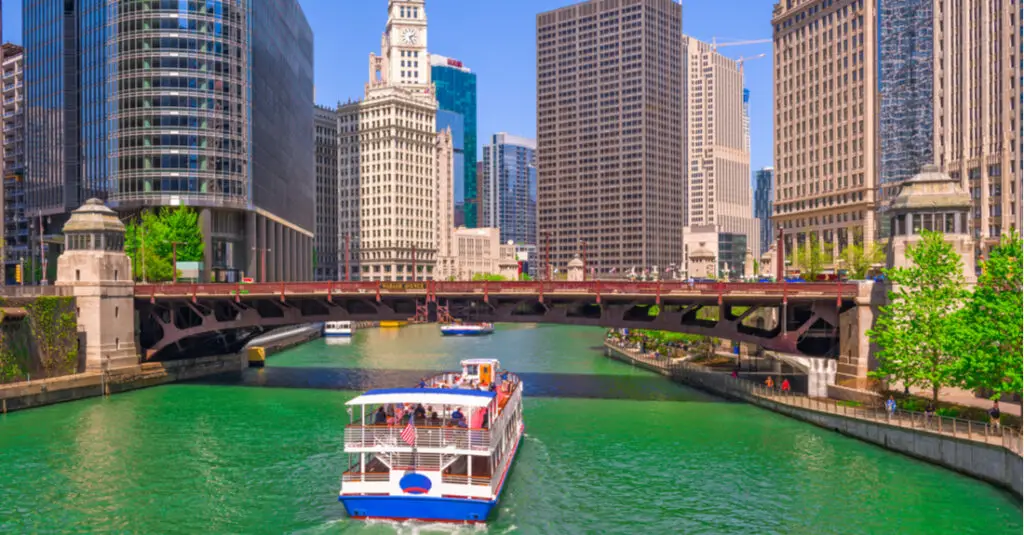
Chicago Riverwalk
- Location: Chicago, Illinois
- Length: 1.25 miles
- River: Chicago River
Bisecting the heart of Chicago, the Chicago Riverwalk offers a fantastic introduction to the Windy City. A walk along the more-than-a-mile-long route leads visitors past some of Chicago’s most notable architectural feats. The Chicago Riverwalk also has public art installations, historical monuments, and delightful bars and restaurants. The Chicago Riverwalk provides the backdrop for many of the city’s most beloved events, perhaps most famously the annual St. Patrick’s Day celebration, which sees the Chicago River dyed bright green.

Charles River Esplanade
- Location: Boston, Massachusetts
- Length: 3 miles
- River: Charles River
The Charles River meanders through the Greater Boston area. Its 17-mile-long bank, home to part of the Charles River Bike Path, provides plenty of space to walk, run and bike. The most popular stretch of this historic riverfront is the Charles River Esplanade. The three-mile-long, 60-plus-acre park in Boston’s Back Bay neighborhood provides opportunities to boat, play sports, or picnic. The Esplanade is also known to be a prime spot for watching Boston’s July 4th fireworks display.
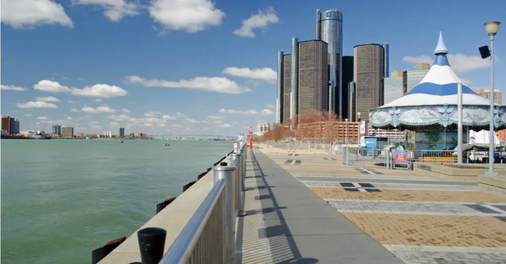
Detroit RiverFront
- Location: Detroit, Michigan
- Length: 4.5 miles
- River: Detroit River
Located along the west bank of the Detroit River, with views of Windsor, Ontario, the Detroit RiverFront provides 4.5 miles of space for relaxation and recreation. Divided into three main sections – the East Riverfront, the West Riverfront, and the Dequindre Cut Greenway – the Detroit RiverFront features walking, jogging and bike paths. The RiverFront also links a number of downtown Detroit’s top attractions, including the Milliken State Park and Lighthouse, Cullen Plaza, and Hart Plaza. For even more recreational space, walk across the MacArthur Bridge to Belle Isle, home to plenty of green space and the popular Belle Isle Aquarium.
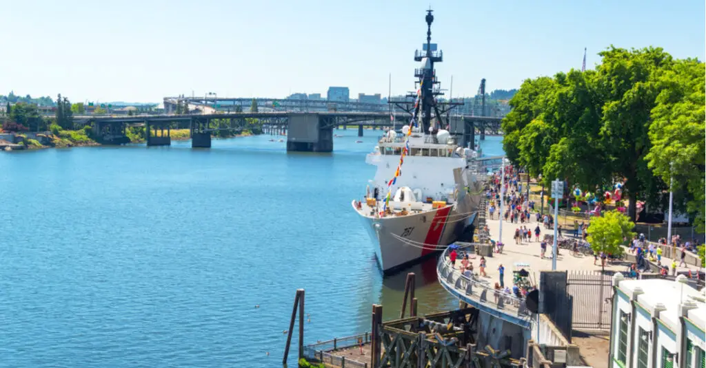
Governor Tom McCall Waterfront Park
- Location: Portland, Oregon
- Length: 1.5 miles
- River: Willamette River
Governor Tom McCall Waterfront Park offers 35 acres of recreational space with views of the Willamette River. Formerly a highway through downtown Portland, the park now houses several of Portland’s top attractions. You can watch the Salmon Street Springs’ 185 computer-controlled water jets dance before exploring the Japanese American Historical Plaza or the Oregon Maritime Museum. On any given day you’ll see Portland residents biking, walking, and jogging along the park’s paved pathways, or simply soaking in the stellar views.
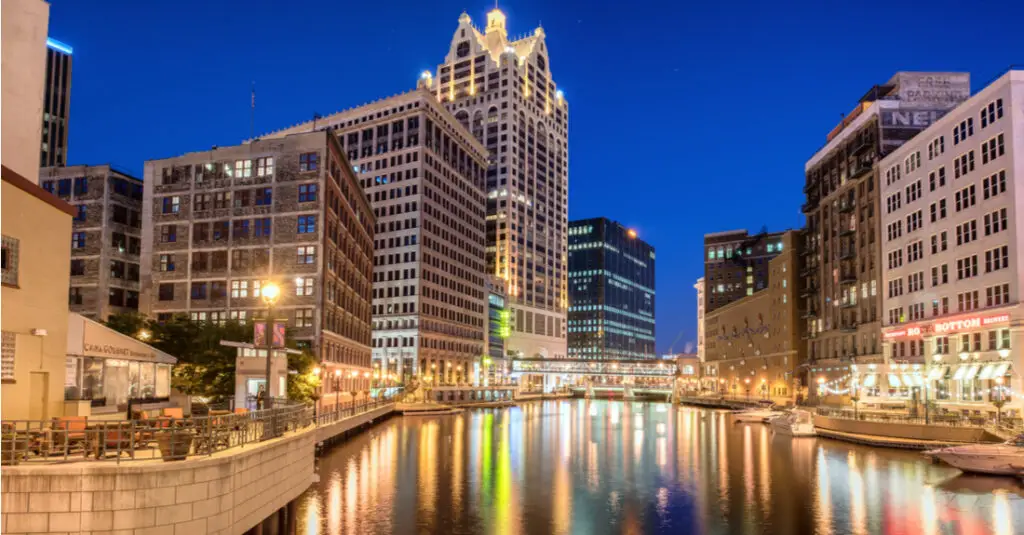
Milwaukee RiverWalk
- Location: Milwaukee, Wisconsin
- Length: 3.1 miles
- River: Milwaukee River
Milwaukee’s RiverWalk runs along both sides of the Milwaukee River, passing through the historic Downtown and Third Ward neighborhoods and ending at Lake Michigan. The Milwaukee RiverWalk provides access to Pere Marquette Park, which hosts popular events like the River Rhythms summer outdoor concert series and Oktoberfest in the fall. Also keep your eyes peeled for the bronze statue of the Fonz from the sitcom Happy Days. The Milwaukee RiverWalk draws walkers, runners and bikers. You can also rent kayaks or canoes, or grab a bite to eat at one of many nearby restaurants.

Reno Riverwalk
- Location: Reno, Nevada
- Length: 0.5 miles
- River: Truckee River
The Reno Riverwalk connects meanderers to top restaurants, attractions and shopping in the Biggest Little City. Occupying a half-mile stretch along the banks of the Truckee River, Reno’s Riverwalk district has experienced a renaissance since the 1990s. Today, the Riverwalk is home to a variety of businesses, including restaurants, bars and hotels. The Riverwalk also provides access to Wingfield Park, where you’ll find boat rentals, picnic areas and outdoor entertainment. The Riverwalk also connects to the Tahoe-Pyramid Bikeway, a 114-mile route connecting Lake Tahoe and Pyramid Lake.
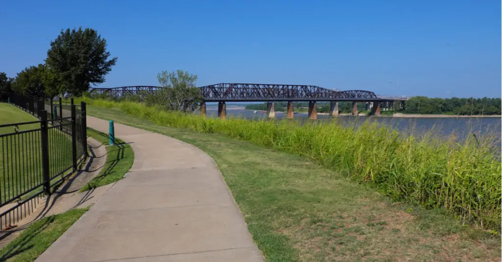
Big River Crossing
- Location: Memphis, Tennessee
- Length: 3.3 miles
- River: Mississippi River
Measuring nearly 1 mile long, the Big River Crossing in Memphis holds the title of the longest pedestrian bridge across the mighty Mississippi River. It’s also the longest active rail, bike and pedestrian bridge in the country. The bridge connects to the 30-acre Tom Lee Park and the 70-plus-mile-long Big River Trail System, providing plenty of opportunities for outdoor recreation. Known officially as the Harahan Bridge, the Big River Crossing offers some of the most spectacular views of Memphis. Visit at night to see the bridge illuminated by more than 100,000 LED lights.
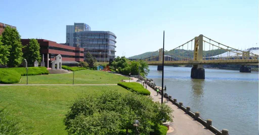
Three Rivers Heritage Trail
- Location: Pittsburgh, Pennsylvania
- Length: 24 miles
- River: Ohio River, Monongahela River, and Allegheny River
The Three Rivers Heritage Trail got its name from its location at the center of Pittsburgh, where the Ohio, the Monongahela and the Allegheny rivers meet. Encompassing nearly 25 miles of riverfront, the Three River Heritage Trail connects a number of Pittsburgh’s top things to do, including the Heinz Field football stadium (home of the Pittsburgh Steelers) and the PNC Park baseball stadium (home of the Pittsburgh Pirates). The Three Rivers Heritage Trail provides plenty of space for walking, jogging and biking, but for those who want more, the trail connects to the 150-mile Great Allegheny Passage.
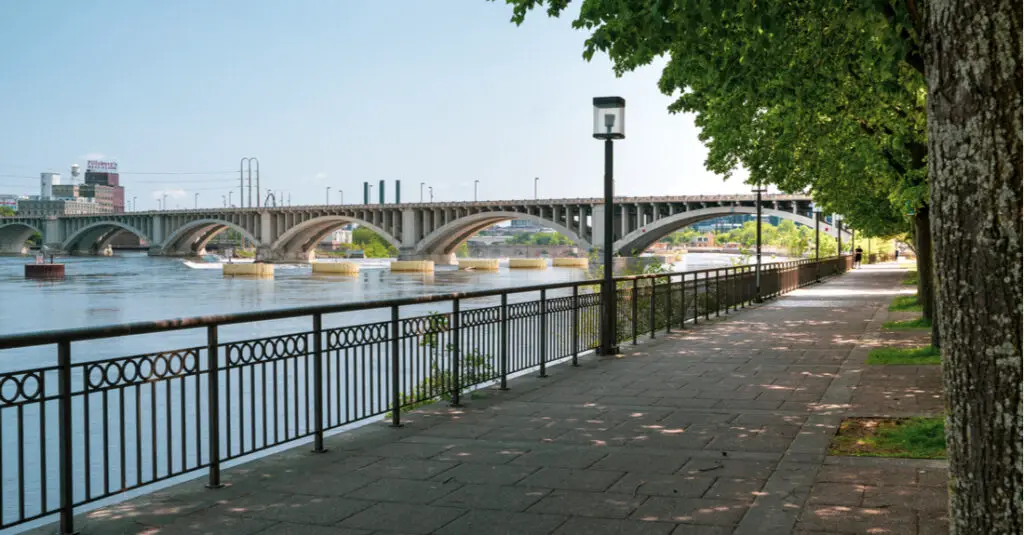
West River Parkway
- Location: Minneapolis, Minnesota
- Length: 7 miles
- River: Mississippi River
Not far from the downtown area, the West River Parkway links several of Minneapolis’ most popular outdoor attractions. This river walk runs along the west bank of the Mississippi River past scenic spots like the Stone Arch Bridge and Above the Falls Park, which overlooks St. Anthony Falls and provides an excellent backdrop for a jog or a bike ride. The West River Parkway connects to several other extensive trails, including the 50-mile Great Rounds Scenic Byway loop, an extensive network of pedestrian pathways and biking trails.

Idaho Falls Greenbelt Trail
- Location: Idaho Falls, Idaho
- Length: 6 miles
- River: Snake River
The Idaho Falls Greenbelt Trail is one of the top attractions in Idaho Falls. Winding 6 miles along the banks of the Snake River, this river walk meanders past scenic spots like the peaceful Japanese Friendship Garden and the 20-foot-high Idaho Falls. The trail is peppered with green spaces, including Russ Freeman Park on the east bank of the river, home to the Idaho State Vietnam Memorial. The northern portion of the Idaho Falls Greenbelt Trail tends to be more crowded given its proximity to Idaho State University. If you prefer to encounter fewer people, head to the southern portion of the river walk, near South Tourist Park.

Trinity Trails
- Location: Fort Worth, Texas
- Length: 100 miles
- River: West Fork Trinity River, Clear Fork Trinity River
The Trinity Trails are like the circulatory system of Fort Worth, providing more than 100 miles of jogging, biking, paddling and horseback riding routes throughout the city. Running along the Trinity River, this trail system offers access to many Fort Worth attractions, including the famous Fort Worth Stockyards. All along the Trinity Trails you’ll discover ways to experience the best of Fort Worth, from the tranquil Rose Garden to the beloved Coyote Drive-In movie theater. You’ll also find a number of local eateries serving hungry trail followers everything from specialty popsicles to craft beer.

Riverfront Canal Walk
- Location: Richmond, Virginia
- Length: 52 miles
- River: James River
Richmond’s historic Riverfront Canal Walk follows the James River for more than a mile through the city center. This riverside path links a number of Richmond attractions, including the Tredegar Iron Works and the American Civil War Museum. Several footbridges provide access from Riverfront Canal Walk to Brown’s Island, where outdoor concerts take place in the summer. The Riverfront Canal Walk is part of the more extensive Virginia Capital Trail. Stretching a total of 52 miles, the Virginia Capital Trail provides access to more of the greater Richmond area’s 550 acres of shoreline.
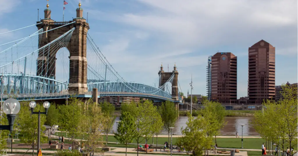
Ohio River Trail
- Location: Cincinnati, Ohio
- Length: 10 miles
- River: Ohio River
The Ohio River Trail includes a total of 10 miles of paths along the Ohio River, which marks the border between Ohio and Kentucky. As it winds 2 miles through downtown Cincinnati, the trail passes several iconic attractions. You’ll see the Paul Brown Stadium where the Cincinnati Bengals play, and the Great American Ball Park, home of the Cincinnati Reds. But the most memorable sight has to be the Purple People Bridge. Connecting downtown Cincinnati to Newport, Kentucky, this pedestrian crossing was painted lilac following a public poll. The bridge offers spectacular views of the city skyline.
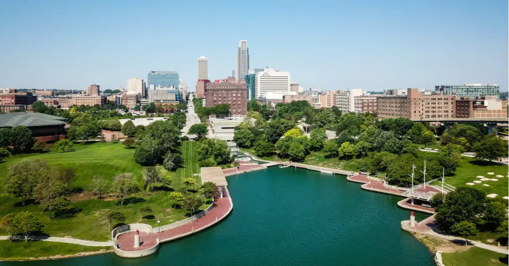
Omaha Riverfront Trail
- Location: Omaha, Nebraska
- Length: 20 miles
- River: Missouri River
The Omaha Riverfront Trail follows the Missouri River 20 miles through downtown Omaha, tracing the border of Nebraska and Iowa. Along the Omaha Riverfront Trail sit numerous green spaces and historic attractions. These include the 3,000-foot-long Bob Kerrey Pedestrian Bridge, the Lewis and Clark Landing, and the Lewis and Clark National Historic Trail headquarters. The Omaha Riverfront Trail provides an excellent place to walk, jog and bike in the downtown area. It also connects to additional trail networks that provide an additional 150 miles of recreation space.
5 Places to Experience Ice Castles in the USA

12 Beautiful Places in the USA to Visit in Winter

10 Beautiful Scenic Drives in Maine

Best Ski Boots For Men – 2024

Ski Boot Deals – December 2024